|
|
|
|
|
|
|
Shuwaihat (Shouwihat,
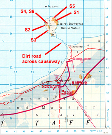
Shouwehat or Shuwayhat) There are two routes to Shuwaihat island. The first, after leaving the main As Sila to Abu Dhabi road at the signpost to "Jazirat Shuwayhat", is across sabkha that might be flooded. The second, mostly on tarmac, is via a road that leads to the General Military Headquarters for the Western Region at Hamra. Both routes pass by a military airstrip that leads to a causeway built in the ?1950s to transport oil drilling equipment to Shuwaihat. There is a capped-off dry well (Site S5) on the island. The island exposes the type section of the Shuwaihat Formation, about 13Ma, (Whybrow et al., 1999; Bristow, 1999) and the majority of Miocene vertebrate fossils from the Emirate of Abu Dhabi have been collected from Baynunah Formation, 6-8Ma, sites at this locality.
Site S1 ( N 24 06' 38.1" E 52 26' 09.6") lies on the western face
of the island's easternmost jebel. This site was one of the two rodent
sampling sites on Shuwaihat (de
Bruijn, 1999; de Bruijn and
Whybrow, 1994), it is also where a partial crocodile skull was found
(Rauhe et al., 1999). Prior
to 1991 we were able to easily examine the eastern part of this jebel
but a military communications area has now been erected and is surrounded
by a fence.
Site S2 (N 24 06' 41.7" E 52 26' 04.0") is the northwestern jebel where much plant material was found
Site S3 (N 24 06' 03.5" E 52 26' 19.0") A UAE survey point (GHQ 4143, height mapped at 47 metres) exists on southern top of the westernmost jebel (known locally as Jebel Mershed). Near to this survey point at site S3 numerous Miocene bivalves were found (Jeffery, 1999).
Site S4 Surrounding the excavation of Site S6, lies the type locality (S4) for Bagrus shuwaiensis Forey and Young, 1999. About 20 metres to its northwest (still within site S4) is the second rodent sampling area, the type locality of Abudhabia baynunensis de Bruijn and Whybrow, 1994.
Site S5 (N 24 07' 06.6" E 52 26' 32.7"). The capped-off well labelled SH-4. This site used as a GPS station.
Site S6 (N 24 06' 44.7" E 52 26' 12.7") is marked by a concrete Natural
History Museum permanent datum (marked BM(NH) 1992) that marks the southern
edge of a major excavation for a proboscidean (Andrews,
1999; Tassy, 1999). Little
sign of this excavation could be seen in 2001 as windblown sand had
filled the depression.
|
![]()
[ Fossil
index - ADIAS home
]
.JPG)
.jpg)
.JPG)
.JPG)
.JPG)
.JPG)
.JPG)
.JPG)
.JPG)